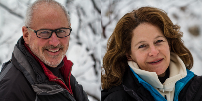
As part of the Great Lakes Project which includes our next book Twenty | Ninety-Five: The Great Lakes Landscapes I headed north to photograph Lake Superior in the winter. I was joined on this trip by fellow photographer Jill Buckner.
When you take a trip like this as part of a bigger project you hope you can return with a few usable images. This means you work long hours and concentrate on the idea behind the project to create images and record the landscape with your own vision. Telling the story of the lakes will be a daunting task. Yet the coexistence of man and nature is always a challenge. With 20% of the world’s fresh water and 95% of North America’s right there in the lakes it is imperative we rethink the partnership between man and the lakes. I will try to bring together the art and science of the issues surrounding our lakes via a book, gallery shows and hopefully a partnership with organizations working on the issues of the lakes.
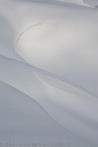
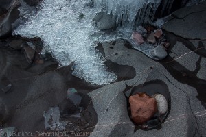
We headed to Pictured Rocks National Lakeshore along the Upper Peninsula of Michigan to begin the trip. We used snow shoes to get to the ice waterfalls and caves, walked on the frozen surface of the lake and spent time with detail images of the snow, ice, the light playing on the trees in the forest and their shadows across the forest floor. There are so many places to turn for great images it was hard to decide where to go next. Often it was based on ease of getting to a location by either snow shoe or cross country skis. The lake here was totally frozen over as far as you could see. The patterns in the ice and snow captured our imaginations.
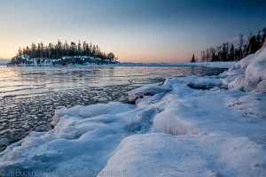
We drove from Pictured Rocks toward Duluth so we could head north to Canada. Along the way we stopped in Marquette. What caught our attention was the fact that Superior was frozen ice as far as you could see until we were near the power plant in Marquette. There we found the water open in an area near the plant clearly showing how man affects the lakes. This is part of our book, talking about how man has lived along the Great Lakes for tens of thousands of years, using them for transportation, hunting, recreation and fresh water to drink and irrigate with. Yet only in the last hundred years have we had so much effect on the quality of the water. We must take that into consideration when we use the lakes. After all, the time it takes to have a drop of water recycled by being swept out into the Atlantic ranges from 4-5 years in Lake Erie to 191 years for Lake Superior.
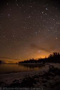
The coast of Minnesota offered rugged terrain and beautiful places to capture the winter along the lake and its ice and cliffs. We spent a night at Split Rock State Park where we photographed the light house in the evening and morning light and even after a snowstorm on the way home. One night after dinner we walked about 50 yards to the beach we camped by and spent a cold, yet rewarding time, making images of the lake with the vast amount stars above and capturing the Milky Way. Sure we were cold, but in all honesty we didn’t think too much about it as we were excited by the creative process. On the way north the next day we hit several state parks and photographed frozen waterfalls, canyons and details of the ice and lake. Many a time we were taken back by the beauty of the lake in winter. The ice seemed to make the reflection of the clouds stand out more than in summer. One of the things we noticed in Minnesota was how clear and glass like the ice there was. In Pictured Rocks National Lakeshore we noticed the ice in the caves was opaque as it contained particles from the streams and earth walls it had flowed over. A very real view of how the water from our land carries with it a little bit of where it came from. Showing us visually that agricultural chemicals, along with whatever we put into streams will show up in our lakes.
In Canada we spent a night at Sleeping Giant Provincial Park which was more of a smooth transition of the forest to the lake. We made our way to the northern most point of the Lake Superior and near Rainbow Falls Provincial Park. We shot in the evening the ice shapes which built up along the shoreline. The thickness and stacking of the ice had us working with different shapes and the blues of the ice to see if we could capture interesting images of the shapes and landscape. At first we heard the ice creaking but realized we were on solid ground still and it was the sound of the water moving underneath the ice.
We headed back down to Minnesota and were blessed with a great snowfall! We had to stop again at some of the same places we’d shot at before and were able to capture many images during the morning light. As I mentioned at the top, on a trip like this you hope to come back with at least some usable images for the project. I think with two photographers and yes one vision, we came back with more than I had hoped for. Here are links to more images.
Pictured Rocks National Lakeshore: www.mackphoto.com/Buckner+Mack/GreatLakes/PicturedRocks/
Minnesota and Canada: www.mackphoto.com/Buckner+Mack/GreatLakes/Superior/
Remember, you can order prints from either of us just by contacting us. Prints will also be available in the store on Quiet Light Publishing in the near future.
Enjoy,
Richard & Jill